The weather’s finally cold enough that there’s time to pour a cup of glühwein, put the feet up by the fire, and finish blog posts about all the being outside this summer that got in the way of posting stuff about being outside on the blog.
So. My first piece of advice to anyone seeking to cross their home country on muscle power alone: move someplace tiny with a complicated border. Like Switzerland.
On the first of September, we rode cycle route 86 from Winterthur to Schaffhausen, via Andelfingen, 31 reasonably-flat-for-Switzerland kilometers, and closed the last gap in an unbroken, muscle-powered trip from St. Louis, France to Gaißau, Austria, across Switzerland.
This is not all that impressive, in that we did it in stages, in no particular order, over several years. The rules are simple though: draw an unbroken red line on a map from France to Austria, such that a red line only gets drawn when we’re moving only under human power or gravity. In order to close a gap, we have to cross the exact point we passed before.
Highlights of the ten stages, in chronological order:
Zürich Oerlikon—Würenlos—Zürich Höngg
This was basically a quick half-day loop ride from to my old flat in Höngg along cycle route 5 (the “Mittelland Route”, or, more honestly “Flat, But A Little Boring”) through fields and past a golf course to a town best known for the fact that it has a hideous blue rest area from the early 80’s straddling the A1 motorway, which I’ve always thought of as The Gateway to Aargau.
Total length of this segment: 17km (of a 31km loop).
Würenlos—Lenzburg—Aarau
This ride somewhen in the late summer of 2012, mainly along the banks of the Aar, was chosen to extend the previous ride in Wallisellen to the house Ariane grew up in in Unterentfelden, to try out my then-shiny-new bike, and to support crossing the country in the other direction, connecting a 2010 ride from Lucerne to Lenzburg via the Seetal and a 2012 ride from Sachseln to Lucern with the Route 29 from Wallisellen to Eglisau via Höhentengen via the Glatt River.
We still haven’t made it any further than Sachseln on the south side, because Sachseln is about as far as you can go in the direction of Italy before it starts getting uncomfortably steep, and most of the nice pass roads are plagued either by terrible weather, insane motorcyclists, or Dutch campervans seeking a shortcut.
At some point in the indeterminate future there will be a From Germany to Italy post, though, and then you’ll know we’re in much better shape.
Total distance of this segment: 46km.
Zürich Oerlikon—Wallisellen—Winterthur
Late in 2012, we took this ride to Winterthur, mainly because the weather was good and we heard there were bagels.
Total distance of this segment: 24km. Total bagels eaten: 2.
Kreuzlingen—Arbon—Gaißau—St. Margarethen
This was the beginning of the 2013 cycling season. We wanted something nice and flat along Lake Constance to start riding again after the long winter in Switzerland and fall in New Zealand. Around about Arbon (which is really surprisingly nice and changed my general impression of little towns in Thurgau), we realized we were feeling fit enough to try to make it all the way to Austria, and make it to Austria we did, crossing the Rhine from Rheineck to Gaißau, stepping off the bikes, realizing we didn’t have any Euro to buy anything at the one little café across the bridge, and turning right back around to the safety of Switzerland. This was the point at which we decided to cross the other way.
Total distance of this segment: 51km. Total time in Austria: 1 minute.
Aarau—Schafmatt—Liestal
From here on out it gets serious, because the goal (which we’d just a couple of weeks before decided was a goal) was in sight. We’d made it as far as Aarau, and we needed to get over to Basel, which is the closest point to Aarau that’ s on the French border. The problem with this is that the Jura’s in the way, and while the Schafmatt is a relatively low pass (at only 820 meters), it’s still a pass. On the way up, we learned that we’re going to have to get in much better shape before we can do the north-south transit. On the way down, we learned that riding downhill is awesome.
Total distance of this segment: 34km. Total stops for air on the way up: 5.
Kreuzlingen—Ermatingen—Berlingen
Switzerland is not really a country for sea kayaking, to the point that when I went to go visit the guys on Granville Island who built my kayak, they knew exactly which boat I was talking about, and asked me to send their greetings to the guy who sold it to me.
Which is a shame, because it has a lot of beautiful flat water to paddle. This segment was the first one way trip of any length that we took in Switzerland, on a bright, cloudless, windless day, from the border at Kreuzlingen, through the middle of Constance on the Seerhein, then along the Untersee (lower Lake Constance) to Ermatigen for lunch and on to Berlingen.
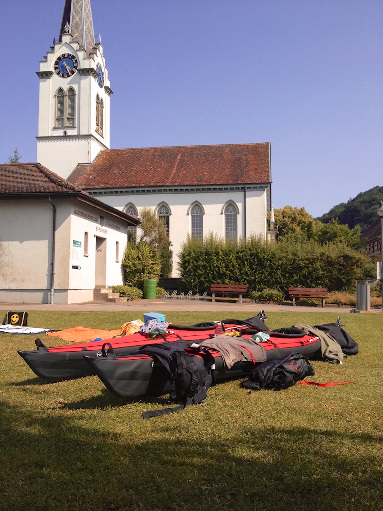
Total length of this segment: 14km. Maximum temperature on the boat deck: 37°. New limit for maximum ambient temperature for middle-distance kayak trips on windless days: 24°.
Berlingen—Wangen—Stein am Rhein
Not too long after I started kayaking in 2004 I set as a goal crossing a border under paddle. My original target for this is still not something I would consider doing without a support boat: the 40-something kilometers from Erie, Pennsylvania to Long Point, Ontario over the open Lake Erie. I know someone who did this once for a charity event in Erie; they were unable to get the necessary permits to do this legally so they just loaded a kayak on the motorboat, crossed in the middle of the night, threw the kayak in the water at Long Point, and paddled back over the next seven or so hours, crossing back into US water before daybreak. I don’t know that I’d risk this nine years later: America seems to take its borders ever more frighteningly seriously.
Crossing from Switzerland to Germany on the Untersee (lower Lake Constance) is, on the other hand, not at all a big deal. But it’s an international border, and I was in a kayak, so it counts. We started where we’d left off in Berlingen, paddled behind and across an amateur regatta, landed briefly in Germany at Wangen, had a sandwich, and paddled into the Rhine just above Stein am Rhein.
Total length of this segment: 16km. Border crossings: 2.
Liestal—Basel—St.Louis
After a bit of paddling, it was time to get on the bike again. From Liestal, where we’d stopped after crossing the Schafmatt, it’s a quick dash to the French border at St. Louis, with the Basel appears from a traffic standpoint to be two cities overlaid on each other. One is a nasty car-ridden mess, and one is much more bicycle friendly than Zürich. Unfortunately, there’s quite a bit of construction going on in the center of Basel, and we got turned around and stuck in the nasty car-ridden mess version of Basel, not realizing we were one or two blocks away from a much nicer path most of the time. We then crossed the Dreiländerbrücke into Germany for a few dozen meters before crossing back to Kleinbasel and catching a train home.
Now we had both ends, and just had to plug the middle.
Total length of this segment: 29km.
Stein am Rhein—Diessenhofen—Schaffhausen
Kayaking the Rhine is a completely different experience than kayaking the Allegheny and Monongahela, where I got my start in Pittsburgh almost a decade ago. For one you can generally see the bottom of the river, as the water’s extremely clear. For another the bottom of the river goes flying by quite quickly, as the current is quite swift. This made the landing in Diessenhofen for lunch somewhat more challenging than I’m used to, but we managed it, and sat down to a refreshing Orangina and a plague of wasps.
Total length of this segment: 16km. Total wasps drowned in one tiny bottle of Orangina: 7.
Winterthur—Andelfingen—Schaffhausen
The original plan was to do this on the boats again, from Andelfingen to Eglisau on the Thur. We’d already ridden from Wallisellen to Eglisau along the Glatt (route 29) a couple of years before, then we’d only have the short gap between Andelfingen and Schaffhausen to do. But the Thur is one of the few uncontrolled rivers in Switzerland, with widely variable flow, and it was too low to paddle. So we hopped a train to Winterthur, rode to Andelfingen to have lunch with friends, then on to Schaffhausen, where we declared victory.
Total distance overall: 278km. Total distance pedalled: 233km. Total distance paddled: 45km.