For the next decade or so, the southern edge of my small home city on the north side of Zürich will be a complex linear construction site, after which we’ll have a segment of a bicycle highway between Zürich and the upper Glatt Valley, and a mostly-brand-new train station with two additional platforms connecting to a new tunnel straight to Winterthur. This is great. But in the meantime, that complex linear construction site has been placed directly over what used to be my bicycle commute, which gave me the opportunity to find a new one.
What I very quickly realized when trying out the possibilities is that I don’t like traffic lights very much. Traffic lights are designed for throughput maximization of high(ish)-speed automotive traffic, and even where they’re timed to minimize the enjoyment of driving your car through the city, where they do have a bicycle phase they’re not particularly friendly to it. This is not much of a problem for my commute; most of the route through the city is either wooded and parklike or residential streets in 30 km/h zones untouchable by the canton, and with a little creative use of Zürich’s former-autobahn-turned-bicycle tunnel, on which more in a bit, I can practically cut my total traffic light count to two: crossing Überlandstrasse at Herzogenmühle, and the top of the Kornhausbrücke at Rousseaustrasse.
In thinking about why these two intersections remain unavoidable, it occurred to me that both of them are where and what they are today because of Zürich’s twentieth century fascination with the automobile, which paralleled the world’s, and sadly reaches into the global polarization of traffic politics in the 21st.
The Y and Its Demise
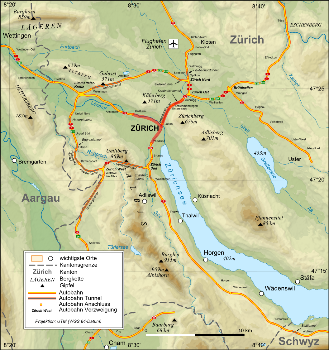
The Ypsilon in its cantonal context. Map by Eric Gaba, NNW, and Pechristener via Wikimedia Commons, CC BY-SA 3.0.
Remember that bicycle tunnel I talked about? It was originally built as part of the construction of the underground Museumstrasse S-Bahn station in the late 1980s, as a pre-investment toward a central autobahn confluence called the Y, giving easy automotive access from all directions directly to the center of the city1. The nearly universal feeling that The Automobile Was The Future created a fear of missing out that overrode the obvious geometric problems with this arrangement2.
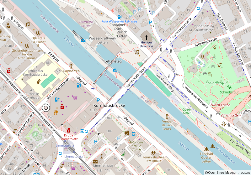
Of course, roads are built in stages, so the road that was to feed the stream of cars into the Y from the north got built as far as the Limmat river as the Milchbucktunnel, which abruptly ends at Wasserwerkstrasse. Turn right, and you end up at the overbuilt-for-Switzerland intersection at the top of the Kornhausbrücke, built to take said stream of cars from the autobahn spur toward Kreis 3.
The most effective way to handle the stream of bicycles from the north on Kornhausstrasse and from the various southern approaches – which to the city’s credit are fairly well built out and have been there for a while, proving its bike infrastructure is not limited by a lack of ability to build it – would be through either bicycle priority or grade separation. Since this trajectory is a key part of the automobile through route in Zürich, it’s managed by the canton, whose politics are captured by the automobile lobby, and therefore won’t allow the former. And the geometry of the site won’t allow the latter3.
The Y and its demise is a fascinating story to me, personally, and not just because I get to cool off at the end every inbound commute by riding my bicycle through an old autobahn tunnel. It’s fascinating because of how cleanly its story mirrors that of the Citizens to Preserve Overton Park, the campaign that stopped the same kind of road from being driven through the green heart of the city I grew up in.
In Memphis, the road was Interstate 40, which the highway planners wanted to run straight through Overton Park – the old-growth woods, the zoo, the art museum, the whole 342-acre lung of midtown. The Automobile Was The Future there too. What stopped it was a group of residents who sued, and who in 1971 won Citizens to Preserve Overton Park v. Volpe at the Supreme Court. I-40 was rerouted onto the northern loop, and the park survived. The cleared right-of-way to its east became Sam Cooper Boulevard, an expressway that accelerates confidently toward midtown and then simply stops at the park’s edge: a stub-end scar of the road that wasn’t built.
The Y died less cleanly. There was no single decision, no Marshall opinion; the anti-Ypsilon initiative the city’s own voters wanted actually lost at the cantonal ballot box in 1974, outvoted by the rest of the canton, as with most of the automotive policy in the city that the canton gets a say about. What killed the Y instead was fifty years of delay, cost, and a slowly shifting consensus, until the federal government finally struck its unbuilt central segment from the national road network plan two years ago. But the shape is the same: two cities, the same mid-century certainty about cars, the same downtown freeway stopped before it could be finished, and the same scars left behind – except that in Zürich, the scar is a tunnel I get to ride my bicycle through.
The Fantasy of Automobiles Always for Everyone Everywhere
The other surviving traffic light sits at Herzogenmühle, where the earlier road across the river – now half bicycle path, dwarfed by the Zürich Ost interchange – crosses Überlandstrasse. The former road has been here in one form or another since at least the 13th century, when a mill on the river belonged to the Grossmünster’s holdings in Schwamendingen. By the 19th century, the river was driving a spinning mill and a printworks. The latter road is what it says it is, Überlandstrasse, overland road, the rural road out of the farming villages surrounding the city.
The reason this five-spoked intersection feels like it belongs in an American suburb is no accident: Schwamendingen was built out from a Swiss farming village to a garden city on the English model, providing housing for the workers in Oerlikon’s factories away from the smoke. The postwar years brought the car, and then the autobahn, which cut Schwamendingen in half for a half century: that fifth spoke belongs to an exit ramp for traffic from the Milchbucktunnel.
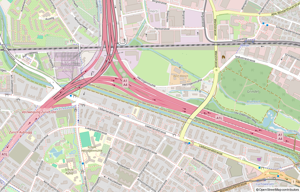
A lot of the damage caused here by the 1960s fantasy of automobiles always for everyone everywhere is being repaired, or at least mitigated. The bifurcation of Schwamendingen by the A1L got a hat with a nice linear park on it, and the truly bonkers inbound interchange toward Milchbuck was removed as part of it. Überlandstrasse got noise protection, and the city fixed the light timing error that, by treating bicycles as an utter afterthought, used to cost me up to ten percent of my daily commute time4.
Zürich isn’t Paris, and it isn’t Amsterdam, but it is trying. The physical damage is the part that mends: the autobahn that dumps all its cars onto the Kornhausbrücke is also noa a tunnel I ride through, the autobahn that cut Schwamendingen in half wears a park, and the bicycle phase at Herzogenmühle no longer resets itself toward infinity. What mends more slowly is the politics that cut the scars in the first place. Taking Tempo 30 out of the hands of the cities and municipalities, a steadfastly antidemocratic move driven largely by parties who purport to stand for democracy, could be seen as clientilism: the Swiss right is so identified with the automobile import, sales, and repair lobby that there was once an Auto Party among their ranks (the recent success of Czechia’s Motorists suggests this might be at least a pan-European phenomenon). But it’s probably more accurate to see it as a lingering belief in the promise of absolute freedom denied, half a century on, in the more marketable costume of keeping the traffic flowing.
So: two traffic lights, the last two places on my commute where the twentieth century reaches up through the asphalt and makes me put a foot down, and both of them sit where they do because someone, once, was certain the future would arrive by car.
(1): this was tied to redeveloping a large industrial area near the tracks at HB into a giant office complex, which after a half century of delay became Europaallee, where my commute ends.
(2): geometric problems that most American cities solved by building parking craters with debt finance; there is a very good argument to be made that vast swathes of Europe were spared from the worst damage the automobile would deal to urban form in the late 20th not through foresight but through more expensive credit.
(3): astute readers of maps and riders of bicycles will note that there is indeed a grade separated bridge into the Schindlergut, kind of a BQE-promenade park leveraged over the mess of the Letten autobahn terminus below. But routing a third of the bicycles that want to cross the Limmat each day into a neighborhood park is also a nonstarter, at least if you want bicycle infrastructure to remain politically tenable. Don’t cut through Schindlergut, kids!
(4): Bus priority is a good thing and the world should have more of it, but the way the city implemented it was via cycle reset: any incoming bus would trip the cycle back to its initial point after the bus passed through. Since the bicycle phase was the final one, if you caught the right sequence of busses you could end up waiting theoretically forever.